
CRISSOLO, VALDIERI, VALLE GESSO, VALLI PO BRONDA E INFERNOTTO
TRAVERSATA PIAN DELLA CASA DEL RE - RIFUGIO REMONDINO
approx. 11 km (4,97 mi)
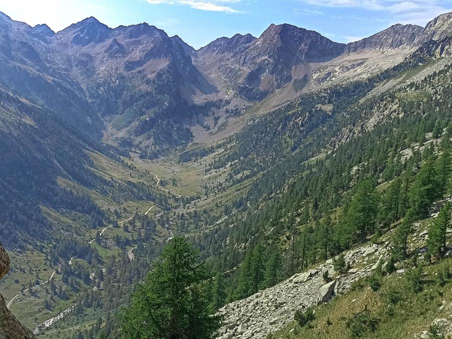
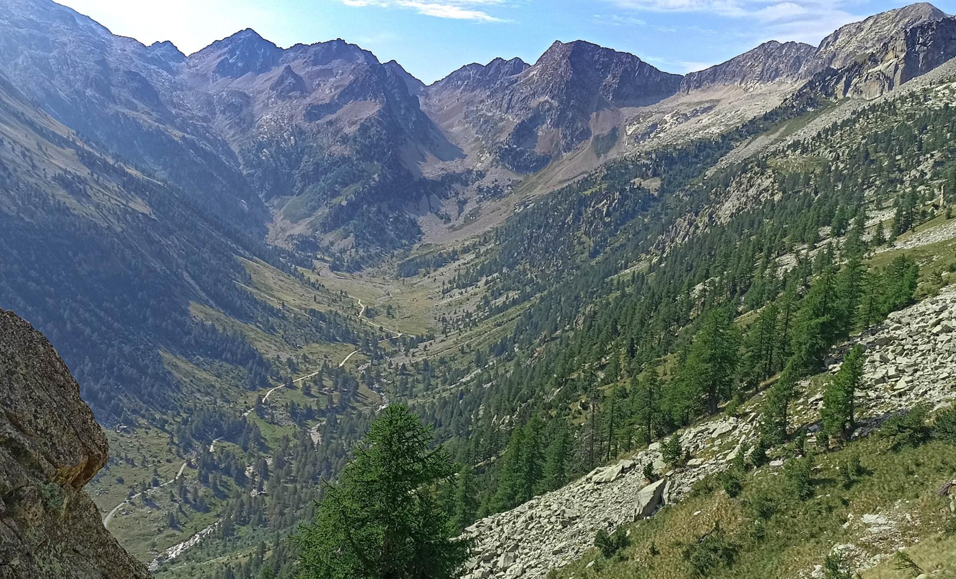
The Assedras and Balma Ghiliè rivers, tributaries of Gesso della Valletta, are connected by a lengthy, high-elevation trail beneath the Nasta, Bastione, Brocan, Ghiliè and Mercantour peaks. An itinerary for true mountain lovers that crosses some of the most solitary, untamed settings of the Maritime Alps, it offers spectacular views of the surrounding peaks and the magnificent plateau of the Fremamorta lakes.
The crossing isn’t particularly difficult, but it’s recommended for experienced hikers because, although marked by signposts, it calls for constant attention to find the right directions. In addition, there may be occasional stretches of snow well into the summer months.
It should be noted that the mountains are an environment subject to constant change and conditions that can vary depending on the weather, the season, climate change, and human influence. The authors and ATL del Cuneese (the Cuneo board of tourism) decline any responsibility for any injury or other harmful consequences deriving from use of the information provided. Each itinerary is to be followed at your own risk.
The Stages
the route
No result found
No result found


Discover
more
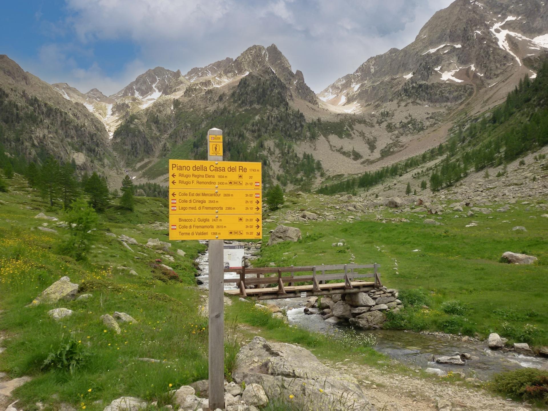
Start: Pian della Casa del Re (Valdieri)
Stage 1: Pian della Casa del Re–Rifugio Remondino
Ascent: approx. 700 m (2,300 ft)
Total length: approx. 3 km (2 mi)
Elevation at start: 1,765 m (5,790 ft)
Highest elevation: 2,464 m (8,084 ft)
Difficulty level: E (intermediate)
From the lower end of the dirt parking area, just before the gate, take the trail that leads to the left towards Rifugio Remondino. This easy mule track starts along a false flat between junipers and larches and passes a spring. Pass a side trail to the right in the direction of Rifugio Regina Elena.
Your trail turns into the Assedras valley and heads more steeply upward. Above an elevation of 2,000 m (6,550 ft), cross the stream over a walkway to the left bank (looking downstream). Passing a side trail to the Balma Ghigliè valley (which will be used for the return trip), continue back across the stream to return to the right bank.
Continue up through numerous switchbacks among increasingly sparse larch trees on the slopes of the steep peaks of Madre di Dio and Maubert. A traverse to the southeast leads to a sort of stony gully to be climbed with the help of more switchbacks.
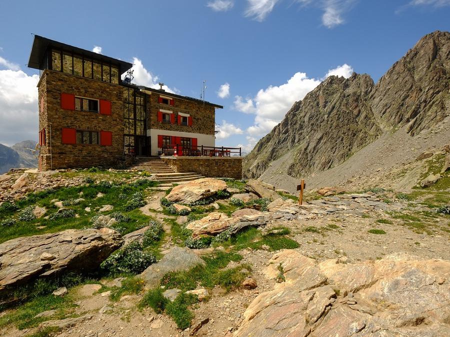
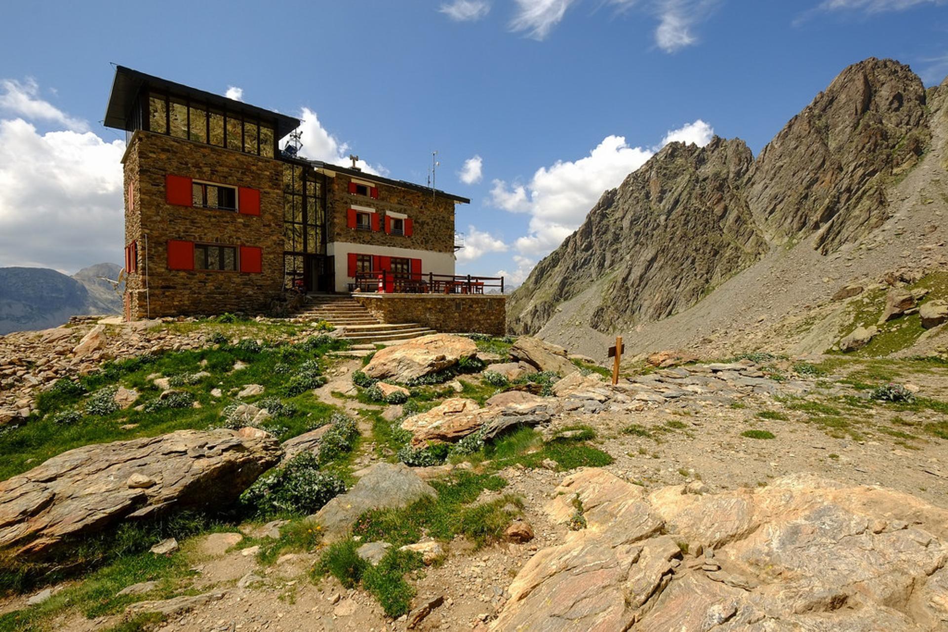
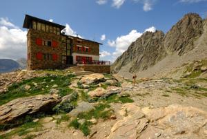
Passing the first side trail to the left to Rifugio Bozano and then another to the impressive Detriti Pass (the standard route for Argentera), continue up rocky steps until you reach the now nearby Rifugio Remondino (2,464 m) perched atop a rocky plateau at the base of the Nasta summit. This alpine shelter is dedicated to Franco Remondino, second lieutenant of the Alpini armed forces and a young up-and-comer of Cuneo mountaineering who died in 1931 on a climb of Rocca Gialeo.
Stage 2: Rifugio Remondino–Pian della Casa del Re by way of Colle Est del Mercantour
Ascent: approx. 350 m (1,150 ft)
Descent: approx. 1,050 m (3,450 ft)
Total length: approx. 8 km (5 mi)
Elevation at start: 2,464 m (8,084 ft)
Highest elevation: 2,800 m (9,190 ft)
Difficulty level: EE (expert)
From the staircase to the entrance of Rifugio Remondino, continue east along a trail that is clearly indicated by white and red markings. After a short flat stretch among boulders and grass, resume climbing up progressively rougher terrain composed first of loose rock, then of compact granite rock, and finally of gneiss.
Approach the rock barrier and, taking advantage of its weak points, climb up the easier formations (easy Class I passages with no exposure) through a series of rocky terraces and hollows. On the way up, Bastione will suddenly appear to the southeast.
With this hard-fought, nearly three hundred meters of elevation gain, you will reach the great upper basin surrounded by the peaks of Nasta, Baus and Bastione. This high-mountain landscape is as rocky as it is inhospitable.
At around 2,770 m (9.090 ft), the white and red markings continue to the right, while a few cairns mark a trail to the left. Ignoring the cairns, continue for a hundred linear meters until the trail splits into two (as indicated on a large boulder).
Keeping to the right, go around the west face of Bastione along an up-and-down trail to reach the highest point of the trek (at 2,800 m). At the bottom is a rocky basin, dotted with tiny, unnamed bodies of water, located in the upper Nasta valley at the foot of the CAI Range.
At a fork in the trail (2,789 m), ignore the trail to the left for Brocan Hill and take the one heading south, mainly downhill and with a few short ascents, first beneath the Brocan summit and then Ghiliè. Although marked in white and red and by cairns, you’ll need to pay close attention to find the right directions.
After a lengthy hike, you’ll reach a sort of rocky plateau. Just above the trail, nestled in a debris-filled hollow at the foot of the Ghiliè summit, is a small unnamed lake (2,662 m) that can be reached with just a short detour.
The trail continues to the right, in the direction of the Mercantour summit, winding its way through undulating, grassy mounds, mountain rocks, and broken stones — disappearing here and there — until you reach the eastern saddle of Mercantour (2,639 m, known as Col du Guilié in French), overlooking Vallon des Erps, which branches off from Vallée du Boréon.
Without crossing into France, turn right on a clearly visible trail again to begin the long descent into the Balma Ghiliè valley. Crossing debris-filled hollows (with some snow possible well into summer), ignore the side trail the left to the western saddle of Mercantour. Along the descent, you will find waterfalls and cross a few streams as the rock gradually transitions into greenery.
The trail descends along a ridge of grass and rock and then passes a gully that plunges downwards towards Pian della Casa del Re. Continuing at the base of a rock wall, you will find a short stretch of military mule track. You will soon pass the remains of the Gias Mercantour (2,222 m) at the end of which, having crossed a stream from the Nasta valley that flows into a dizzying gorge, you will begin a steep zig-zagging descent into a gully flanked by vertical rock faces.
When you reach the trail to Rifugio Remondino, you will have completed the loop. All you have to do is retrace your steps back to Pian della Casa del Re.